As campuses grow in size and complexity, whether in higher education, healthcare, or corporate environments, navigating these vast spaces has become increasingly difficult. Traditional paper maps and static signage often fall short in providing the flexibility and accuracy required to meet the dynamic needs of students, visitors, and staff. This is where interactive maps come in—a smart solution revolutionizing campus navigation and transforming facilities and resource management.
What Are Interactive Maps?
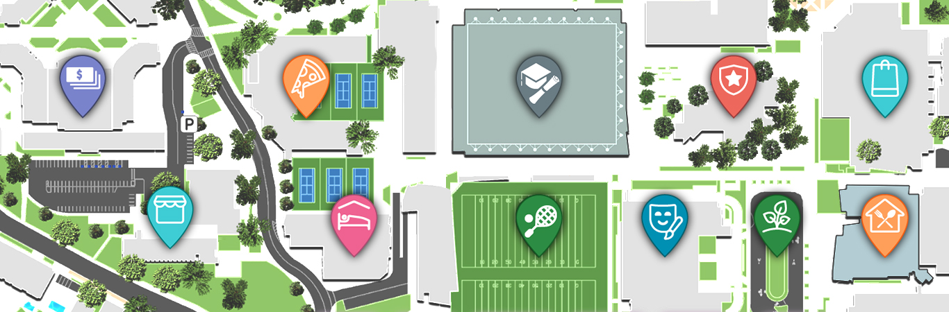
Interactive maps are digital tools designed to provide real-time, personalized navigation and resource information. Unlike traditional maps, interactive maps are dynamic and customizable, enabling users to access precise location data, route recommendations, and updates on campus facilities. These maps can be accessed through kiosks, mobile apps, or web portals, ensuring accessibility for everyone.
Incorporating technologies like GPS, IoT (Internet of Things), and real-time data integration, interactive maps go beyond simple navigation. They offer features like live updates on building occupancy, equipment tracking, and route optimization, making them indispensable for modern campuses.
Streamlining Campus Navigation
One of the primary roles of interactive maps is simplifying campus navigation. Whether a new student trying to locate a lecture hall or a visitor attending a conference, interactive maps provide turn-by-turn directions tailored to their needs.
- Real-Time Updates: Interactive maps integrate with campus systems to provide real-time updates on closures, construction zones, or event schedules, ensuring users are always informed.
- Accessibility: These maps cater to all users by including ADA-compliant routes, multilingual support, and audio guidance for individuals with visual impairments.
- Dynamic Routing: Interactive maps adjust routes based on real-time factors like crowd density, emergencies, or time constraints, ensuring efficient navigation.
Enhancing Facilities Management
Interactive maps are not just tools for navigation—they are powerful resources for facilities and resource management teams. By integrating with campus management systems, these maps enable administrators to monitor and optimize operations efficiently.
1. Asset Tracking and Maintenance
Interactive maps allow facilities managers to pinpoint the location of campus assets, such as HVAC systems, furniture, or IT equipment. By linking these maps with IoT sensors or asset management tools, teams can:
- Monitor the condition and usage of assets.
- Schedule timely maintenance or replacements to avoid costly breakdowns.
- Reduce operational costs by streamlining service routes for maintenance staff.
2. Space Utilization
Understanding how campus spaces are used is critical for effective resource management. Interactive maps provide data on room occupancy, foot traffic patterns, and vacant spaces. This information helps:
- Optimize space assignments for classrooms, meeting rooms, or event venues.
- Identify underutilized areas and repurpose them for better efficiency.
- Guide individuals to available rooms or resources, saving time and reducing frustration.
3. Emergency Preparedness
In emergencies, interactive maps provide real-time data that is crucial for quick decision-making:
- Facilities managers can visualize building layouts and coordinate evacuations efficiently.
- Emergency personnel can locate critical systems like fire exits or shut-off valves.
- Users can access safe routes and emergency instructions directly through the map interface.
Promoting Sustainability
Interactive maps contribute to a more sustainable campus environment by promoting eco-friendly practices:
- Highlighting walking or biking routes to reduce the reliance on vehicles.
- Displaying information about energy-efficient buildings or green-certified facilities.
- Encouraging resource optimization by identifying energy consumption trends and suggesting improvements.
Integrating Interactive Maps with Smart Campus Systems
The true potential of interactive maps lies in their integration with broader smart campus ecosystems. By connecting with systems like smart parking, shuttle services, or building automation, these maps offer a seamless experience:
- Display live parking availability and guide drivers to open spots.
- Show shuttle schedules and routes, enabling users to plan multi-modal trips.
- Sync with room booking systems to help staff and students reserve spaces on the go.