K-12 School Critical Incident Mapping - Vicinia

K-12 School Critical Incident Mapping

Vicinia K-12 School
Critical Incident Mapping

Precise. Secure. Ready. Whenever and wherever seconds matter.
Emergency Response Map

Our Promise

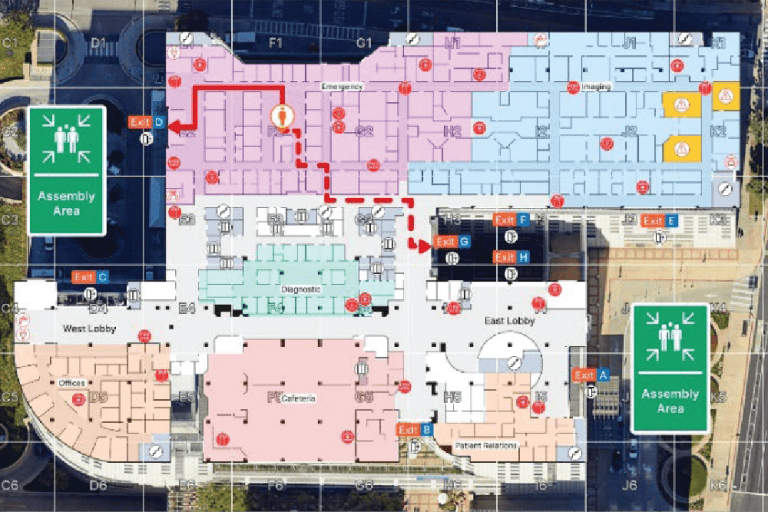
Schools need more than maps—they need a trusted partner in safety. Vicinia delivers purpose-built school emergency response maps backed by years of experience in educational environments. Our critical incident mapping platform delivers precision in digital floor plans and campus layouts, tightly integrated with key safety systems, so that administrators and first responders operate with clarity, speed, and confidence. 

Campus Map
Critical Incident Mapping - Evacuation Plan

What We Deliver

  • Accurate Indoor Mapping – Scaled floor plans with labeled rooms, stairwells, hazard zones, utility sources, AEDs, and trauma kits. 
  • Verified Campus Layouts – High-resolution aerial overlays highlighting parking, fields, roadways, entry points, and perimeter properties. 
  • Multi-Layered Safety Intelligence – Supporting ADA routes, dynamic safety asset overlays, and optional 360° walkthroughs to enrich situational awareness. 
  • Direct First Responder Access – Safe, real-time emergency response map access delivered to 911 dispatch centers, law enforcement, fire, and EMS via our Open API. 
  • Safe, Secure & Compliant – U.S.-based data creation, storage, and management that aligns with state/federal mandates and best practices. 

Ecosystem-Ready Integrations

Vicinia works where your tools already work: 

  • CAD & Dispatch Platforms 
  • RapidSOS — 911 API linkage 
  • Security Systems — Verkada, Milestone, AI gun detection (ZeroEyes, Omnilert, VOLT AI) 
  • Safety Suites — Raptor, Rave, Everbridge, CENTEGIX 

Leverage your existing investments—with no added software or fees. 

integrations
Indoor Zoning

Built for Compliance & Funding

  • Compliant with all major state emergency response mapping mandates and aligned with national guidance like the PASS Guidelines and CISA.  
  • Designed to fit within funding frameworks such as state allocations or federal grant programs. 
  • Built to scale, evolve, and remain ready for future legislation. 

Next Steps

  • Schedule a Live Demo – See Vicinia maps in action and understand how they work with your systems.  
  • Join a State Webinar – Get clarity on your state’s specific safety mapping mandate.  
  • Get Started with Confidence – Equip your district with ready-to-use, mission-critical incident mapping. 

Vicinia: Your partner in critical incident mapping.
Prepared, connected, empowered.

Book a Demo